Spoiled Hike
Disc Golf and Cabins in the Shenandoah Mountains
Lydia Mountain Trails

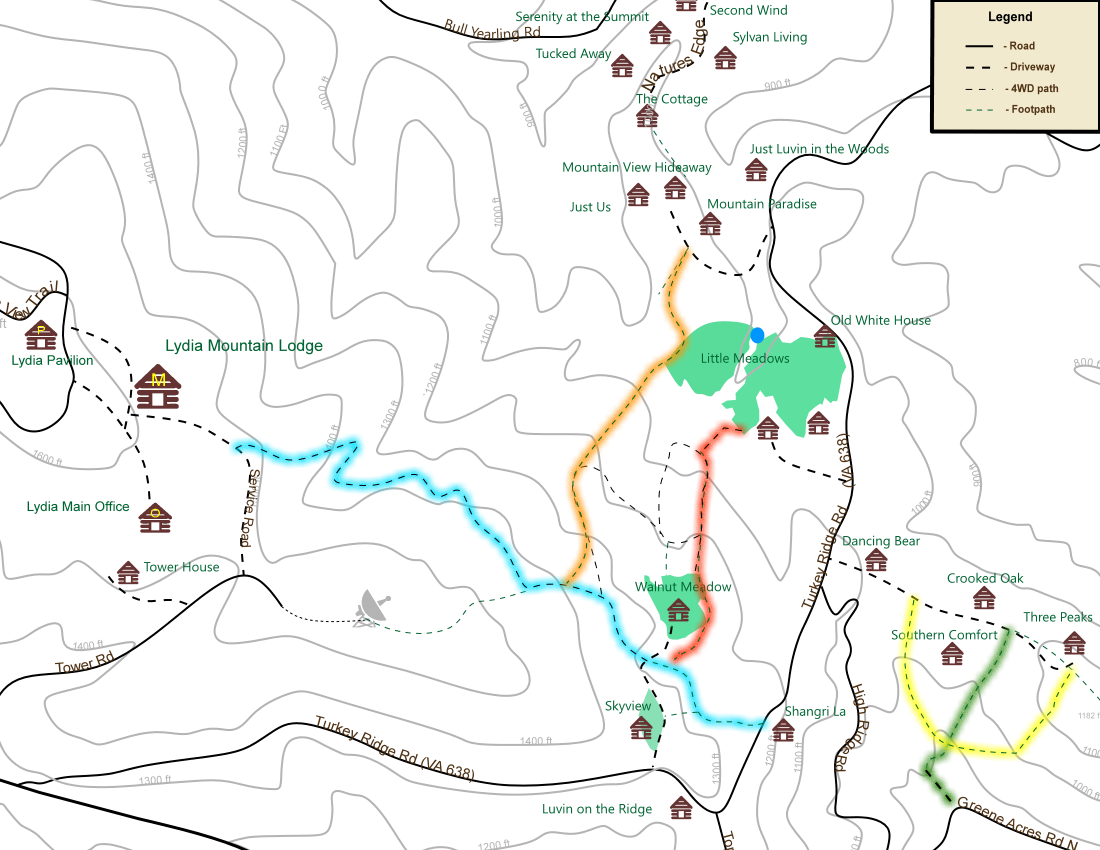
There are lots of places to walk, but two of them are of particular interest:
- Shangri-La to Lydia Mountain Lodge. If you are on the southern half of Turkey Ridge Rd and you need a bite to eat (assuming the restaraunt is open), this is the way to go.
- The Unspoiled Hike: The outer portions of the disc golf course around Southerm C0mfort make a 0.7 mile circuit of medium difficulty. Some sections are quite steep, especially on the north slope. Most of the trail is also disc golf fairway, but there is a non-fairway trail alongside the gulley SW of Southern Comfort.
The colored trails are all blazed except for the new orange one. Here's is a printable Lydia Trail Map.
Shenandoah National Park Trails - East Side
While the easiest way into the park is to drive up to Skyline drive, this presents a basic problem to the erstwhile hiker: You must commence your hike by walking downhill and finish it by walking up. Some alternatives to this somewhat undesirable circumstance are hereby and thusforthly presented:
- Entry Run Trail. A fifteen minute drive the the trailhead of this hidden gem.
- Pocosin Hollow Trail. Just north of Entry Run Trail.
- Power Line Trail. The shortest route to SNP. Connects the PATC cabins on Goose Pond Rd to the Appalachian Trail.
- Jones Mountain Just over the border in Madison county. In a secluded area of the park for a slightly more liberating experience. A longer trail where one can spend a full day hiking; picnic and all.
- Old Rag. A half hour drive to the most difficult, and most popular hike in the Park
Shenandoah National Park Trails - Skyline Drive
- South River Falls. It goes downhill first, but if you only have a few hours, you can't do any better than this. Drive up US 33 into the park, head north on Skylinw drive and check into the first parking lot on the right. See bottom of this Map.I'm looking for a way up Kirtley Mountain.
- Hoover retreat. A must see if in the area. A camp full of interesting and little known facts. A hike that includes a waterfall. Excellent for those interested in combining a hike with an historical experience.
Links
- Potomac
Appalachian Trail Club
Awesome maps, which can be ordered directly from the club, or purchased at SNP entrances. We're at the bottom right corner of Map #10, and just off the top end of map #11. They also have a several cabins for rent in the area that are generally a) cheaper, b) more remote, and c) more primitive. In particular, there is a cluster of five on the other side of U.S. 33 and two more off of Entry Run trail. -
Shenandoah
National Park
Link for maps and trails up top, especially the Lewis Mountain area - Midatlantic
Hikes
More online maps . I like maps,
does it show? -
Rapidian Wildlife Management Area.